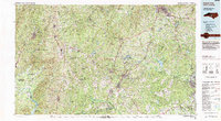
1982 Map of Southern Pines
USGS Topo · Published 1983About this map
The Uwharrie National Forest and the Uwharrie Mountains anchor the western edge of this region, transitioning into the sprawling sandy pine barrens that define the Fort Bragg Military Reservation to the southeast. In the early 1980s, the landscape was a complex mosaic of timberlands, military training grounds, and established rail towns. The Seaboard Coast Line and Norfolk Southern railways intersect at vital hubs like Southern Pines, Aberdeen, and Sanford, tracing the industrial corridors of the Moore County area.
Find a feature on this map
119 named features on this map. Tap any name to fly to it.
Don’t see what you’re looking for? This feature index may not catch every label — zoom into the map to look around manually.
Map Details
Editions of this 1982 Southern Pines Map
This is the sole edition of this map. No revisions or reprints were ever made.
Other maps of this area

1941 · Spartanburg
USGS Topo · 1:250,000

1942 · Troy
USGS Topo · 1:125,000

1942 · Rockingham
USGS Topo · 1:125,000

1948 · Southern Pines
USGS Topo · 1:62,500

1948 · Fayetteville
USGS Topo · 1:62,500

1948 · Clifdale
USGS Topo · 1:62,500

1948 · Pinebluff
USGS Topo · 1:24,000

1948 · Nicholson Creek
USGS Topo · 1:24,000

1948 · Clifdale
USGS Topo · 1:24,000

1948 · Mc Cain
USGS Topo · 1:24,000