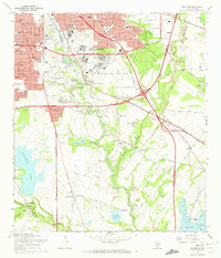
1967 Map of Southton
USGS Topo · Published 1970About this map
San Antonio River meanders south from the city, passing a series of landmark colonial Spanish sites preserved as the San Jose Mission National Historic Site. The landscape in the late 1960s is a mix of urban expansion, military installations, and industrial extraction. Significant aviation footprints are visible at Brooks Air Force Base and Stinson Municipal Airport, while the southeastern corner is dominated by the Braunig Lake reservoir and its adjacent Powerplant. Moving toward the settlement of Southton, the terrain is marked by numerous Gravel Pits and the sprawling grounds of the Southton Sanatorium. The confluence of the river with the Medina River near Earle highlights the hydrologic network that supported early agricultural communities like Bergs Mill and Buena Vista, before modern infrastructure like Goliad Road reshaped the valley's transit.
Find a feature on this map
64 named features on this map. Tap any name to fly to it.
Don’t see what you’re looking for? This feature index may not catch every label — zoom into the map to look around manually.
Map Details
Editions of this 1967 Southton Map
3 editions found
Other maps of this area

1953 · San Antonio West
USGS Topo · 1:24,000

1953 · San Antonio East
USGS Topo · 1:24,000

1953 · Terrell Wells
USGS Topo · 1:24,000

1953 · Elmendorf
USGS Topo · 1:24,000

1953 · Southton
USGS Topo · 1:24,000

1953 · Martinez
USGS Topo · 1:24,000

1954 · San Antonio
USGS Topo · 1:250,000

1957 · San Antonio
USGS Topo · 1:250,000

1958 · Losoya
USGS Topo · 1:24,000

1958 · Thelma
USGS Topo · 1:24,000