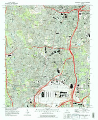
1993 Map of Southwest Atlanta
USGS Topo · Published 1995About this map
Fort McPherson Military Reservation and the sprawling footprint of the Hartsville-Atlanta International Airport dominate the southern half of this landscape, illustrating the heavy institutional and logistical infrastructure that shaped this portion of Fulton County by the early 1990s. The map reveals a dense residential and academic fabric in the northern reaches, including Morehouse College, Spelman College, and Clark Atlanta University, alongside historic burial grounds like Westview Cemetery and Greenwood Cemetery.
Find a feature on this map
120 named features on this map. Tap any name to fly to it.
Don’t see what you’re looking for? This feature index may not catch every label — zoom into the map to look around manually.
Map Details
Editions of this 1993 Southwest Atlanta Map
2 editions found

Other maps of this area

1888 · Atlanta
USGS Topo · 1:125,000

1890 · Atlanta
USGS Topo · 1:125,000

1891 · Marietta
USGS Topo · 1:125,000

1892 · Atlanta
USGS Topo · 1:125,000

1895 · Atlanta
USGS Topo · 1:125,000

1895 · Marietta
USGS Topo · 1:125,000

1897 · Marietta
USGS Topo · 1:125,000

1901 · Marietta
USGS Topo · 1:125,000

1953 · Atlanta
USGS Topo · 1:250,000

1954 · Conley
USGS Topo · 1:24,000