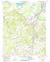
1974 Map of Southwest Goldsboro
USGS Topo · Published 1992About this map
The Neuse River and its intricate drainage systems define the landscape southwest of the city, where the Seaboard Coast Line railroad creates a north-south corridor for industry and settlement. Small communities and rail-side stops like Genoa, Brogden, and Dudley anchor the eastern half of the map, while the western reaches are dominated by the winding path of Falling Creek and the expansive Thoroughfare Swamp.
Find a feature on this map
48 named features on this map. Tap any name to fly to it.
Don’t see what you’re looking for? This feature index may not catch every label — zoom into the map to look around manually.
Map Details
Editions of this 1974 Southwest Goldsboro Map
2 editions found
Other maps of this area

1953 · Rocky Mount
USGS Topo · 1:250,000

1953 · Raleigh
USGS Topo · 1:250,000

1954 · Rocky Mount
USGS Topo · 1:250,000

1954 · Raleigh
USGS Topo · 1:250,000

1957 · Goldsboro
USGS Topo · 1:62,500

1957 · Seven Springs
USGS Topo · 1:62,500

1974 · Grantham
USGS Topo · 1:24,000

1974 · Northwest Goldsboro
USGS Topo · 1:24,000
1974 · Princeton
USGS Topo · 1:24,000

1974 · Southwest Goldsboro
USGS Topo · 1:24,000