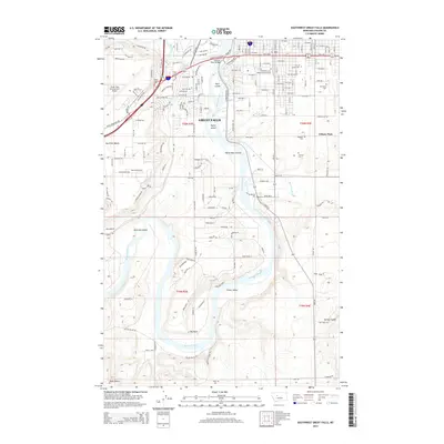
2014 Map of Southwest Great Falls
USGS Topo · Published 2014About this map
The Missouri River carves a winding path through this portion of Great Falls, defining a landscape of prominent islands and elevated benches. In this 2014 survey, the river is dotted with significant landforms including Park Island, Taylor Island, and the White Bear Islands, while further downstream, the waterway makes a sharp turn at Big Bend near Fisher Island. The urban and suburban expansion of the city is evident, stretching from the campus of the University of Great Falls and the cluster of memorial sites like Hillcrest Lawn Memorial Association and Mt Olivet Cemetery toward the residential pockets of Eden Acres.
Find a feature on this map
116 named features on this map. Tap any name to fly to it.
Don’t see what you’re looking for? This feature index may not catch every label — zoom into the map to look around manually.
Map Details
Editions of this 2014 Southwest Great Falls Map
This is the sole edition of this map. No revisions or reprints were ever made.
Other maps of this area

1886 · Great Falls
USGS Topo · 1:250,000

1948 · Portage
USGS Topo · 1:62,500

1949 · Portage
USGS Topo · 1:62,500

1949 · Great Falls
USGS Topo · 1:62,500

1951 · Great Falls
USGS Topo · 1:62,500

1954 · Great Falls
USGS Topo · 1:250,000

1955 · Stockett
USGS Topo · 1:62,500

1955 · Gore Hill
USGS Topo · 1:62,500

1957 · Great Falls
USGS Topo · 1:250,000
1965 · Manchester
USGS Topo · 1:24,000