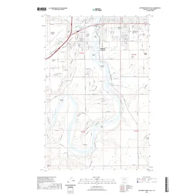
2020 Map of Southwest Great Falls
USGS Topo · Published 2020About this map
The Missouri River winds through this landscape, creating a series of distinctive landforms including Park Island, Taylor Island, and the White Bear Islands. On the western bluffs, the Great Falls International Airport occupies the high ground of Gore Hill overlooking the city. The urban grid of Great Falls is balanced by academic and commemorative spaces, notably the Univ of Great Falls and several large burial grounds such as Highland Cem and Mount Olivet Cem. South of the city center, the terrain transitions into the agricultural expanse of Gibson Flats and the elevated Truly Bench. The confluence where the Sun River meets the Missouri highlights the historical importance of these waterways to the region's development and transport network.
Find a feature on this map
111 named features on this map. Tap any name to fly to it.
Don’t see what you’re looking for? This feature index may not catch every label — zoom into the map to look around manually.
Map Details
Editions of this 2020 Southwest Great Falls Map
This is the sole edition of this map. No revisions or reprints were ever made.
Other maps of this area

1886 · Great Falls
USGS Topo · 1:250,000

1948 · Portage
USGS Topo · 1:62,500

1949 · Portage
USGS Topo · 1:62,500

1949 · Great Falls
USGS Topo · 1:62,500

1951 · Great Falls
USGS Topo · 1:62,500

1954 · Great Falls
USGS Topo · 1:250,000

1955 · Stockett
USGS Topo · 1:62,500

1955 · Gore Hill
USGS Topo · 1:62,500

1957 · Great Falls
USGS Topo · 1:250,000
1965 · Manchester
USGS Topo · 1:24,000