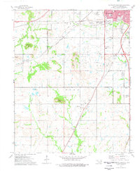
1974 Map of Southwest Muskogee
USGS Topo · Published 1978About this map
The Old Indian Treaty Boundary carves through this Oklahoma landscape just southwest of Muskogee, marking a historical line of territorial demarcation. The terrain is characterized by prominent rises like Chimney Mountain, Hofschulte Hill, and Baucum Hill, while the rural outskirts are dotted with small community landmarks such as Crekola and Summit. The area south of the Hatbox Field airport reveals an active Oil Field, where a network of radio towers and a local Quarry indicate the region's industrial footprint.
Find a feature on this map
45 named features on this map. Tap any name to fly to it.
Don’t see what you’re looking for? This feature index may not catch every label — zoom into the map to look around manually.
Map Details
Editions of this 1974 Southwest Muskogee Map
This is the sole edition of this map. No revisions or reprints were ever made.
Other maps of this area

1896 · Okmulgee
USGS Topo · 1:125,000

1900 · Okmulgee
USGS Topo · 1:125,000

1901 · Muscogee
USGS Topo · 1:125,000

1905 · Muscogee
USGS Topo · 1:125,000

1946 · Fort Smith
USGS Topo · 1:250,000

1948 · Keefeton
USGS Topo · 1:62,500

1948 · Wagoner
USGS Topo · 1:62,500

1950 · Keefeton
USGS Topo · 1:62,500

1950 · Wagoner
USGS Topo · 1:62,500

1965 · Fort Smith
USGS Topo · 1:250,000