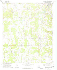
1972 Map of Southwest Pontotoc
USGS Topo · Published 1974About this map
The Skuna River and its numerous tributaries, including Funny Creek and Little Skuna River, carve through this rural landscape southwest of the city of Pontotoc. In the early 1970s, this region was characterized by a dense network of country churches that served as community anchors, such as Macedonia Union Ch, Reynolds Chapel, and Palestine Ch. The northern portion of the map shows the expansion of Pontotoc near Pontotoc Lake, while the village of Algoma sits further south along the Gulf Central Illinois rail line. A notable institutional presence is the Pontotoc Ridge-Flatlands State Experiment Station in the southeast, indicating the area's ongoing importance to agricultural research. From the South Pontotoc Attendance Center to the various sandpits scattered near Webster Creek, the map illustrates a landscape shaped by both local education and small-scale natural resource extraction.
Find a feature on this map
32 named features on this map. Tap any name to fly to it.
Don’t see what you’re looking for? This feature index may not catch every label — zoom into the map to look around manually.
Map Details
Editions of this 1972 Southwest Pontotoc Map
This is the sole edition of this map. No revisions or reprints were ever made.
Other maps of this area

1949 · New Albany
USGS Topo · 1:62,500

1951 · New Albany
USGS Topo · 1:62,500

1955 · Sherman
USGS Topo · 1:62,500

1956 · Tupelo
USGS Topo · 1:250,000

1958 · Tupelo
USGS Topo · 1:250,000

1966 · Troy NW
USGS Topo · 1:24,000

1966 · Troy
USGS Topo · 1:24,000

1972 · Houlka
USGS Topo · 1:24,000

1972 · Robbs
USGS Topo · 1:24,000

1972 · Randolph
USGS Topo · 1:24,000