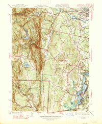
1947 Map of Southwick
USGS Topo · Published 1947About this map
Sodom Mountain and Drake Mountain dominate the central ridge of this mid-century survey, dividing the landscape between the upland plateaus of Granville and the lower river valleys to the east. The Westfield River and Little River carve through the north, with the notable Little River Gorge and Power House marking the industrial and natural intersection of the terrain. Near the town of Southwick, the College Highway serves as a primary north-south artery, passing near the Southwick Depot and the expansive Congamond Lakes system at the Connecticut border. The map provides a detailed view of the rural infrastructure of the era, from the West Parish Filters and Westfield Reservoir to numerous family-named landmarks and cemeteries like Pine Hill Cem and Rice Cem. Local recreational development is also evident at the Hilltop Trail Golf Course and Cooley Lake, reflecting the post-war character of this Massachusetts-Connecticut borderland.
Find a feature on this map
71 named features on this map. Tap any name to fly to it.
Don’t see what you’re looking for? This feature index may not catch every label — zoom into the map to look around manually.
Map Details
Editions of this 1947 Southwick Map
3 editions found
Other maps of this area

1886 · Springfield
USGS Topo · 1:62,500

1887 · Granville
USGS Topo · 1:62,500

1889 · Springfield
USGS Topo · 1:62,500

1889 · Granville
USGS Topo · 1:62,500

1892 · Hartford
USGS Topo · 1:62,500

1892 · Granby
USGS Topo · 1:62,500

1893 · Springfield
USGS Topo · 1:62,500

1893 · Granville
USGS Topo · 1:62,500

1895 · Springfield
USGS Topo · 1:62,500

1895 · Granville
USGS Topo · 1:62,500