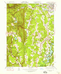
1947 Map of Southwick
USGS Topo · Published 1947About this map
The New York New Haven and Hartford railroad cuts a distinct vertical path through the eastern corridor of this 1940s landscape, connecting the water-rich basin of the Congamond Lakes to the industrial outskirts of Westfield. This survey captures the transition from the rugged western uplands of Sodom Mountain and Badluck Mtn down toward the managed agricultural and recreation lands of Southwick. Local institutions like the West Parish Church and Southwick Ch serve as social anchors for settlements such as Mundale and Gillett Corner. Water management is a primary theme of the terrain, visible in the extensive Aqueduct system and the Westfield Reservoir, which utilize the natural drainages of Munn Brook and the Westfield River to support the region's growth.
Find a feature on this map
119 named features on this map. Tap any name to fly to it.
Don’t see what you’re looking for? This feature index may not catch every label — zoom into the map to look around manually.
Map Details
Editions of this 1947 Southwick Map
3 editions found
Other maps of this area

1886 · Springfield
USGS Topo · 1:62,500

1887 · Granville
USGS Topo · 1:62,500

1889 · Springfield
USGS Topo · 1:62,500

1889 · Granville
USGS Topo · 1:62,500

1892 · Hartford
USGS Topo · 1:62,500

1892 · Granby
USGS Topo · 1:62,500

1893 · Springfield
USGS Topo · 1:62,500

1893 · Granville
USGS Topo · 1:62,500

1895 · Springfield
USGS Topo · 1:62,500

1895 · Granville
USGS Topo · 1:62,500