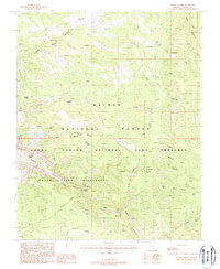
1988 Map of Sowats Spring
USGS Topo · Published 1988About this map
Sowats Spring and the surrounding high desert plateaus of Coconino County are defined by a complex network of drainage systems and isolated water sources. This 1980s survey captures the intersection of three major protected areas: the Kaibab National Forest, the Grand Canyon National Game Preserve, and the Kanab Creek Wilderness. The topography is dominated by deep incisions such as Big Sowats Canyon and Slide Canyon, while landforms like Sawmill Point and West Lake Point overlook the rugged terrain. Reliance on scarce water is evident through numerous cattle tanks and natural seeps, including Bone Hollow Tank, South Side Tank, and Box Elder Spring. Strategic mountain gaps like Eagle Pass and Ranger Pass provide the only logical routes through the jagged vertical relief of the Kaibab Plateau's western edge.
Find a feature on this map
25 named features on this map. Tap any name to fly to it.
Don’t see what you’re looking for? This feature index may not catch every label — zoom into the map to look around manually.
Map Details
Editions of this 1988 Sowats Spring Map
2 editions found
Other maps of this area

1886 · Kaibab
USGS Topo · 1:250,000

1953 · Grand Canyon
USGS Topo · 1:250,000

1957 · Grand Canyon
USGS Topo · 1:250,000

1957 · Jumpup Canyon
USGS Topo · 1:62,500

1958 · Grand Canyon
USGS Topo · 1:250,000

1958 · Big Springs
USGS Topo · 1:62,500

1960 · Grand Canyon
USGS Topo · 1:250,000

1962 · Kanab Point
USGS Topo · 1:62,500
1962 · Powell Plateau
USGS Topo · 1:62,500

1984 · Grand Canyon
USGS Topo · 1:100,000