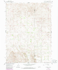
1960 Map of Spalding 2 SE
USGS Topo · Published 1985About this map
Mud Creek winds through the southern reaches of this landscape, cutting through the complex topography of southeastern Wheeler County during the mid-twentieth century. The terrain is characterized by intricate landforms and depressions typical of this part of Nebraska, providing a detailed look at the rural environment before later developments. The map highlights the essential local infrastructure of the era, specifically showing the placement of rural education centers like School No 19 in the southwest and School No 39 further east. The boundary between Wheeler Co and Boone Co runs vertically through the eastern portion of the sheet, marking a significant administrative divide for genealogists and local historians tracing land ownership and residency across county lines during the late 1950s and early 1960s.
Find a feature on this map
4 named features on this map. Tap any name to fly to it.
Don’t see what you’re looking for? This feature index may not catch every label — zoom into the map to look around manually.
Map Details
Editions of this 1960 Spalding 2 SE Map
3 editions found
Other maps of this area

1954 · Spalding
USGS Topo · 1:24,000

1954 · Akron
USGS Topo · 1:24,000

1954 · Spalding NW
USGS Topo · 1:24,000

1955 · Broken Bow
USGS Topo · 1:250,000

1956 · Broken Bow
USGS Topo · 1:250,000

1960 · Spalding 2 SW
USGS Topo · 1:24,000

1960 · Spalding 2 NW
USGS Topo · 1:24,000

1960 · Spalding 2 NE
USGS Topo · 1:24,000

1960 · Spalding 2 SE
USGS Topo · 1:24,000

1963 · Elgin NW
USGS Topo · 1:24,000