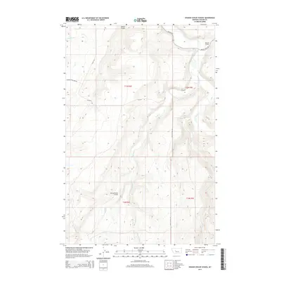
2014 Map of Spanish Coulee School
USGS Topo · Published 2014About this map
The Smith River winds through this section of Montana's high country, joined by various drainage systems like Hound Cr and Mullens Cr. The landscape is defined by its dramatic relief, where the north-flowing river has cut deep into the terrain, creating significant physical barriers between the uplands. This 2014 survey documents the enduring ranching and rural infrastructure of the region, anchored by the Spring Willow Coulee settlement area. Transportation across these breaks relies on a network of high-altitude routes including Millegan Rd and Upper Millegan Rd, which navigate the complex topography between Spanish Coulee and Murphy Coulee. Further north and west, the headwaters of Flat Cr and its forks suggest the watershed's transition toward the Missouri River basin, while local landmarks like Boston Coulee Rd highlight the naming conventions of the area's early homesteaders and ranchers.
Find a feature on this map
20 named features on this map. Tap any name to fly to it.
Don’t see what you’re looking for? This feature index may not catch every label — zoom into the map to look around manually.
Map Details
Editions of this 2014 Spanish Coulee School Map
This is the sole edition of this map. No revisions or reprints were ever made.
Other maps of this area

1886 · Great Falls
USGS Topo · 1:250,000

1949 · Cascade
USGS Topo · 1:62,500

1951 · Cascade
USGS Topo · 1:62,500

1954 · Great Falls
USGS Topo · 1:250,000

1955 · Gore Hill
USGS Topo · 1:62,500

1957 · Great Falls
USGS Topo · 1:250,000

1961 · Schrammeck Lake
USGS Topo · 1:24,000

1961 · Dana Ranch
USGS Topo · 1:24,000

1965 · Eden
USGS Topo · 1:24,000
1965 · Truly
USGS Topo · 1:24,000