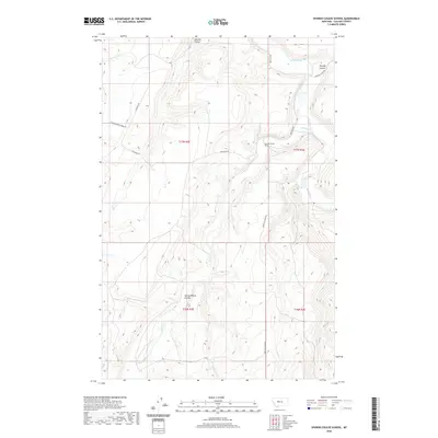
2020 Map of Spanish Coulee School
USGS Topo · Published 2020About this map
Spanish Coulee School serves as a central landmark in this portion of Cascade County, where the high plains are deeply incised by a network of drainage coulees and seasonal creeks. The terrain is defined by the winding course of the Smith River and its major tributaries, including Hound Cr and Mullens Cr. This landscape is partitioned by long-established rural routes like Millegan Rd and Ten Mile Rd, which follow the natural contours of the breaks. Local geography is named for these prominent landforms, such as Spanish Coulee, Murphy Coulee, and Spring Willow Coulee. The map provides a detailed view of the water system feeding into the Smith River valley, capturing everything from the W-Fork Flat Cr to the spring-fed draws like Spring Cr that support this ranching and grazing country.
Find a feature on this map
21 named features on this map. Tap any name to fly to it.
Don’t see what you’re looking for? This feature index may not catch every label — zoom into the map to look around manually.
Map Details
Editions of this 2020 Spanish Coulee School Map
This is the sole edition of this map. No revisions or reprints were ever made.
Other maps of this area

1886 · Great Falls
USGS Topo · 1:250,000

1949 · Cascade
USGS Topo · 1:62,500

1951 · Cascade
USGS Topo · 1:62,500

1954 · Great Falls
USGS Topo · 1:250,000

1955 · Gore Hill
USGS Topo · 1:62,500

1957 · Great Falls
USGS Topo · 1:250,000

1961 · Schrammeck Lake
USGS Topo · 1:24,000

1961 · Dana Ranch
USGS Topo · 1:24,000

1965 · Eden
USGS Topo · 1:24,000
1965 · Truly
USGS Topo · 1:24,000