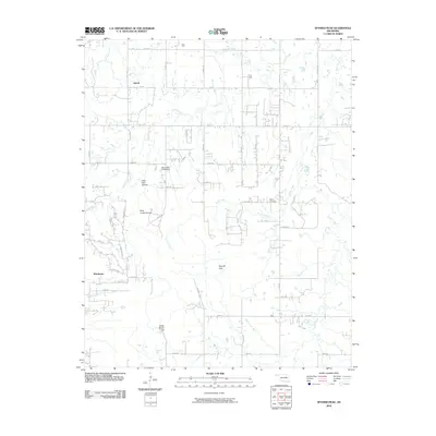
2010 Map of Spanish Peak
USGS Topo · Published 2010About this map
Duck Creek and its various tributaries, including Eagle Creek and Snake Creek, define the drainage patterns of this section of Oklahoma just south of the Tulsa area. The settlement of Liberty sits in the northern portion of the map, while the community of Winchester is established further south along a network of section line roads like Garber Rd and Hall Rd. This 2010 digital survey captures the transition of the landscape into rural residential tracts and small ranches, evidenced by features such as Dude Ranch Hill. The terrain is punctuated by small landmarks including Spanish Peak and the evocative Hoot Owl Hollow. For those researching local family ties, the Bruner Cemetery remains a significant focal point, situated near the headwaters of Bruner Creek. The inclusion of the Oknoname 111018 Dam highlights the modern management of these Oklahoma waterways.
Find a feature on this map
51 named features on this map. Tap any name to fly to it.
Don’t see what you’re looking for? This feature index may not catch every label — zoom into the map to look around manually.
Map Details
Editions of this 2010 Spanish Peak Map
This is the sole edition of this map. No revisions or reprints were ever made.
Other maps of this area

1896 · Okmulgee
USGS Topo · 1:125,000

1900 · Okmulgee
USGS Topo · 1:125,000

1901 · Nuyaka
USGS Topo · 1:125,000

1914 · Kiefer
USGS Topo · 1:62,500

1916 · Kiefer
USGS Topo · 1:62,500

1946 · Fort Smith
USGS Topo · 1:250,000

1954 · Oklahoma City
USGS Topo · 1:250,000

1957 · Leonard
USGS Topo · 1:24,000
1957 · Bixby
USGS Topo · 1:24,000

1957 · Oklahoma City
USGS Topo · 1:250,000