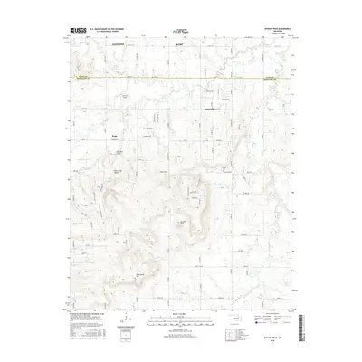
2016 Map of Spanish Peak
USGS Topo · Published 2016About this map
Spanish Peak rises as a prominent landmark in the landscape south of Bixby and Glenpool, marking a terrain defined by the boundary between Tulsa and Okmulgee counties. The area is characterized by a transition from the developing residential grids of the north to the more secluded valleys of the south, where Hoot Owl Hollow and Rock Creek Canyon wind through the hills. This 2016 survey documents the complex network of rural roads and section lines, including Happy Camp Rd and Ferguson Rd, that connect small settlements like Hectorville and Beggs. The map provides specific detail for local history, showing the location of the Bruner Cem near Bruner Cr and the specialized landing strip at Erroport Airport. From the banks of Duck Cr to the heights of Dude Ranch Hill, the sheet illustrates a mix of agricultural pasture and suburban expansion.
Find a feature on this map
49 named features on this map. Tap any name to fly to it.
Don’t see what you’re looking for? This feature index may not catch every label — zoom into the map to look around manually.
Map Details
Editions of this 2016 Spanish Peak Map
This is the sole edition of this map. No revisions or reprints were ever made.
Other maps of this area

1896 · Okmulgee
USGS Topo · 1:125,000

1900 · Okmulgee
USGS Topo · 1:125,000

1901 · Nuyaka
USGS Topo · 1:125,000

1914 · Kiefer
USGS Topo · 1:62,500

1916 · Kiefer
USGS Topo · 1:62,500

1946 · Fort Smith
USGS Topo · 1:250,000

1954 · Oklahoma City
USGS Topo · 1:250,000

1957 · Leonard
USGS Topo · 1:24,000
1957 · Bixby
USGS Topo · 1:24,000

1957 · Oklahoma City
USGS Topo · 1:250,000