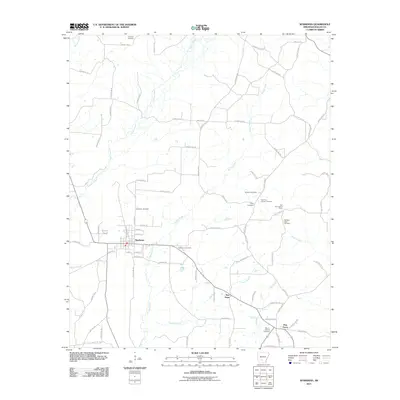
2011 Map of Sparkman
USGS Topo · Published 2011About this map
Sparkman sits as a central hub of local transit and commerce within this Dallas County landscape, anchored by a grid of streets including Stuart St and Kelly Ave N. The surrounding countryside is defined by an intricate network of waterways such as Cypress Creek, Brushy Creek, and Hall Creek, which dictate the placement of rural homesteads and connecting routes like County Hwy-33. For family historians, the sheet is exceptionally well-marked with burial sites, ranging from the Holeman Cemetery in the north to Mount Carmel Cemetery near Pine Grove in the south.
Find a feature on this map
79 named features on this map. Tap any name to fly to it.
Don’t see what you’re looking for? This feature index may not catch every label — zoom into the map to look around manually.
Map Details
Editions of this 2011 Sparkman Map
This is the sole edition of this map. No revisions or reprints were ever made.
Other maps of this area

1903 · Camden
USGS Topo · 1:125,000

1953 · El Dorado
USGS Topo · 1:250,000

1955 · Little Rock
USGS Topo · 1:250,000

1956 · Little Rock
USGS Topo · 1:250,000

1957 · El Dorado
USGS Topo · 1:250,000

1958 · El Dorado
USGS Topo · 1:250,000

1960 · El Dorado
USGS Topo · 1:250,000

1960 · Little Rock
USGS Topo · 1:250,000

1964 · Little Rock
USGS Topo · 1:250,000
1965 · Dalark
USGS Topo · 1:24,000