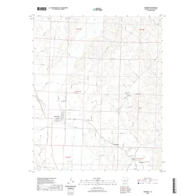
2020 Map of Sparkman
USGS Topo · Published 2020About this map
Sparkman serves as the primary hub in this Dallas County landscape, where a grid of town streets like N Railroad Ave and E Main St meets the rural timber and creek lands of south-central Arkansas. The area is exceptionally rich in small family and community burial grounds, including the Holeman Cem to the north and Williams Cem further east, providing a dense network of sites for genealogical research. The terrain is defined by the winding paths of Cypress Cr and Brushy Cr, which cut through the various sections of the Public Land Survey System townships. Smaller settlements like New Hope and Pine Grove anchor the southern reaches of the map, while the inclusion of the Mount Carmel Cem and Harmony Church Cem suggests the long-standing role of country churches in organizing local community life across these woods.
Find a feature on this map
38 named features on this map. Tap any name to fly to it.
Don’t see what you’re looking for? This feature index may not catch every label — zoom into the map to look around manually.
Map Details
Editions of this 2020 Sparkman Map
This is the sole edition of this map. No revisions or reprints were ever made.
Other maps of this area

1903 · Camden
USGS Topo · 1:125,000

1953 · El Dorado
USGS Topo · 1:250,000

1955 · Little Rock
USGS Topo · 1:250,000

1956 · Little Rock
USGS Topo · 1:250,000

1957 · El Dorado
USGS Topo · 1:250,000

1958 · El Dorado
USGS Topo · 1:250,000

1960 · El Dorado
USGS Topo · 1:250,000

1960 · Little Rock
USGS Topo · 1:250,000

1964 · Little Rock
USGS Topo · 1:250,000
1965 · Dalark
USGS Topo · 1:24,000