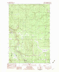
1982 Map of Sparrow Rapids
USGS Topo · Published 1983About this map
The Ottawa National Forest dominates this landscape in Michigan's Upper Peninsula, where the East Branch Ontonagon River carves a winding path through the townships of Duncan and Laird. As of the late 1970s field check, the area remains primarily a wilderness of timber and water, marked by an extensive network of Old RR Grade remnants that speak to the region's logging history. These former rail lines weave between numerous water bodies, including York Lake, Duck Lake, and the remote Davidson Lakes.
Find a feature on this map
26 named features on this map. Tap any name to fly to it.
Don’t see what you’re looking for? This feature index may not catch every label — zoom into the map to look around manually.
Map Details
Editions of this 1982 Sparrow Rapids Map
This is the sole edition of this map. No revisions or reprints were ever made.
Other maps of this area

1949 · Rockland
USGS Topo · 1:62,500

1951 · Rockland
USGS Topo · 1:62,500

1952 · Watersmeet
USGS Topo · 1:62,500

1954 · Rousseau
USGS Topo · 1:62,500

1954 · Kenton
USGS Topo · 1:62,500

1958 · Iron River
USGS Topo · 1:250,000

1960 · Iron River
USGS Topo · 1:250,000

1961 · Iron River
USGS Topo · 1:250,000

1967 · Iron River
USGS Topo · 1:250,000

1979 · Ontonagon
USGS Topo · 1:100,000