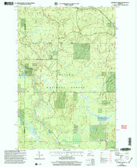
1999 Map of Sparrow Rapids
USGS Topo · Published 2004About this map
Kenton and the surrounding wilderness of the Ottawa National Forest define this landscape along the border of Ontonagon and Houghton counties. The area is characterized by the winding path of the East Branch Ontonagon River, which passes through the namesake Sparrow Rapids. This 1999 revision captures a unique point in local forest history, marking the Site of 1986 National Christmas Tree and the location of the Camp Kenton CCC Camp Site, reflecting decades of federal land management and conservation efforts.
Find a feature on this map
28 named features on this map. Tap any name to fly to it.
Don’t see what you’re looking for? This feature index may not catch every label — zoom into the map to look around manually.
Map Details
Editions of this 1999 Sparrow Rapids Map
This is the sole edition of this map. No revisions or reprints were ever made.
Other maps of this area

1949 · Rockland
USGS Topo · 1:62,500

1951 · Rockland
USGS Topo · 1:62,500

1952 · Watersmeet
USGS Topo · 1:62,500

1954 · Rousseau
USGS Topo · 1:62,500

1954 · Kenton
USGS Topo · 1:62,500

1958 · Iron River
USGS Topo · 1:250,000

1960 · Iron River
USGS Topo · 1:250,000

1961 · Iron River
USGS Topo · 1:250,000

1967 · Iron River
USGS Topo · 1:250,000

1979 · Ontonagon
USGS Topo · 1:100,000