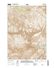
2017 Map of Sparta
USGS Topo · Published 2017About this map
Sparta sits near the northern boundary of this Baker County landscape, its history tied to the surrounding drainage networks of the Powder River and Eagle Creek Canyon. The terrain is characterized by a dense system of gulches, including the descriptively named Hole in the Wall Gulch and Rattlesnake Gulch. These natural features dictated the early infrastructure of the region, visible in the winding paths of Gem Mine Rd and Seismograph Rd. Water management is prominent through features like the Dry Gulch Ditch and Wyatt Reservoir, which support the high-elevation flats and canyons.
Find a feature on this map
45 named features on this map. Tap any name to fly to it.
Don’t see what you’re looking for? This feature index may not catch every label — zoom into the map to look around manually.
Map Details
Editions of this 2017 Sparta Map
This is the sole edition of this map. No revisions or reprints were ever made.
Other maps of this area

1915 · Pine
USGS Topo · 1:125,000

1955 · Baker
USGS Topo · 1:250,000

1957 · Halfway
USGS Topo · 1:62,500

1957 · Sparta
USGS Topo · 1:62,500

1957 · Durkee
USGS Topo · 1:62,500

1957 · Mineral
USGS Topo · 1:62,500

1959 · Baker
USGS Topo · 1:250,000

1981 · Baker
USGS Topo · 1:100,000
1987 · Richland
USGS Topo · 1:24,000
1987 · Jimtown
USGS Topo · 1:24,000