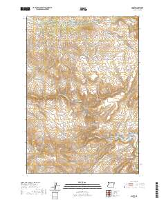
2020 Map of Sparta
USGS Topo · Published 2020About this map
Sparta sits at the northern edge of this high-desert landscape in Baker County, where the historic mining and ranching legacy is still visible through its road network and named landmarks. The local geography is defined by an intricate system of drainages including Eagle Creek Canyon and Rattlesnake Gulch, all flowing toward the prominent Powder River which cuts through the southern half of the quadrangle. Genealogists and historians can locate the Sparta Cem and trace old transit routes like Gem Mine Rd and Hash Knife Rd, which speak to the area's industrial and agricultural roots. The presence of the Dry Gulch Ditch and Wyatt Reservoir highlights the critical role of water management in this arid terrain, while peculiar names like Hole in the Wall Gulch and Skin-it Gulch reflect the colorful local vernacular of early settlers and prospectors.
Find a feature on this map
46 named features on this map. Tap any name to fly to it.
Don’t see what you’re looking for? This feature index may not catch every label — zoom into the map to look around manually.
Map Details
Editions of this 2020 Sparta Map
This is the sole edition of this map. No revisions or reprints were ever made.
Other maps of this area

1915 · Pine
USGS Topo · 1:125,000

1955 · Baker
USGS Topo · 1:250,000

1957 · Halfway
USGS Topo · 1:62,500

1957 · Sparta
USGS Topo · 1:62,500

1957 · Durkee
USGS Topo · 1:62,500

1957 · Mineral
USGS Topo · 1:62,500

1959 · Baker
USGS Topo · 1:250,000

1981 · Baker
USGS Topo · 1:100,000
1987 · Richland
USGS Topo · 1:24,000
1987 · Jimtown
USGS Topo · 1:24,000