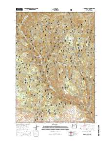
2014 Map of Sparta Butte
USGS Topo · Published 2014About this map
Whitman National Forest dominates this section of Baker County, where the high-elevation terrain is carved by a dense network of gulches and creeks. Rising above the drainage of Shanghai Cr and Sawmill Cr, Sparta Butte stands as a prominent landmark. The landscape is defined by the steep descent into Eagle Creek Canyon, where Eagle Cr and its many tributaries, such as Puzzle Cr and Forshey Cr, have deeply eroded the mountain slopes.
Find a feature on this map
49 named features on this map. Tap any name to fly to it.
Don’t see what you’re looking for? This feature index may not catch every label — zoom into the map to look around manually.
Map Details
Editions of this 2014 Sparta Butte Map
This is the sole edition of this map. No revisions or reprints were ever made.
Other maps of this area

1915 · Pine
USGS Topo · 1:125,000

1954 · Cornucopia
USGS Topo · 1:62,500

1954 · Eagle Cap
USGS Topo · 1:62,500

1955 · Baker
USGS Topo · 1:250,000

1955 · Grangeville
USGS Topo · 1:250,000

1957 · Halfway
USGS Topo · 1:62,500

1957 · Sparta
USGS Topo · 1:62,500

1959 · Baker
USGS Topo · 1:250,000

1959 · Grangeville
USGS Topo · 1:250,000

1981 · Baker
USGS Topo · 1:100,000