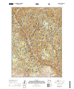
2020 Map of Sparta Butte
USGS Topo · Published 2020About this map
The Eagle Creek Wild and Scenic River carves a deep path through this corner of the Whitman National Forest in Baker County. This 2020 landscape is defined by its significant relief, featuring numerous named drainages such as Six Dollar Gulch, Empire Gulch, and Town Gulch. These features, along with the prominent Sparta Butte and Eagle Creek Canyon, reveal a terrain shaped by water and timber management. Modern recreational use is evident through an extensive network of specialized routes like the Lily White Snowmobile and Eagle Drive Snowmobile trails. Historical land use is further indicated by local infrastructure such as Stoddard Reservoir and the Martin Bridge crossing, while water sources like Torchlight Spring and Fizz Spring suggest the importance of spring-fed hydrology in this part of eastern Oregon.
Find a feature on this map
48 named features on this map. Tap any name to fly to it.
Don’t see what you’re looking for? This feature index may not catch every label — zoom into the map to look around manually.
Map Details
Editions of this 2020 Sparta Butte Map
This is the sole edition of this map. No revisions or reprints were ever made.
Other maps of this area

1915 · Pine
USGS Topo · 1:125,000

1954 · Cornucopia
USGS Topo · 1:62,500

1954 · Eagle Cap
USGS Topo · 1:62,500

1955 · Baker
USGS Topo · 1:250,000

1955 · Grangeville
USGS Topo · 1:250,000

1957 · Halfway
USGS Topo · 1:62,500

1957 · Sparta
USGS Topo · 1:62,500

1959 · Baker
USGS Topo · 1:250,000

1959 · Grangeville
USGS Topo · 1:250,000

1981 · Baker
USGS Topo · 1:100,000