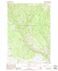
1988 Map of Sparta Butte
USGS Topo · Published 1988About this map
Sparta Butte stands as a prominent landmark in this eastern Oregon landscape, which is largely defined by the drainage networks of Eagle Creek and its many tributaries. Surveyed in the late 1980s, the area reflects a history of small-scale resource extraction and livestock management within the Whitman National Forest. Scattered mining activity is evident through features like the Amalgamated Mine and various unnamed prospects and mines tucked into the drainages of Tackle Gulch and Town Gulch.
Find a feature on this map
41 named features on this map. Tap any name to fly to it.
Don’t see what you’re looking for? This feature index may not catch every label — zoom into the map to look around manually.
Map Details
Editions of this 1988 Sparta Butte Map
This is the sole edition of this map. No revisions or reprints were ever made.
Other maps of this area

1915 · Pine
USGS Topo · 1:125,000

1954 · Cornucopia
USGS Topo · 1:62,500

1954 · Eagle Cap
USGS Topo · 1:62,500

1955 · Baker
USGS Topo · 1:250,000

1955 · Grangeville
USGS Topo · 1:250,000

1957 · Halfway
USGS Topo · 1:62,500

1957 · Sparta
USGS Topo · 1:62,500

1959 · Baker
USGS Topo · 1:250,000

1959 · Grangeville
USGS Topo · 1:250,000

1981 · Baker
USGS Topo · 1:100,000