
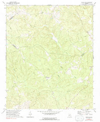
1972 Map of Sparta NW
USGS Topo · Published 1974About this map
Powelton stands as a focal point in this rural landscape where the boundaries of Greene, Taliaferro, and Hancock counties converge. The topography is defined by an intricate network of waterways, including the upper reaches of the Ogeechee River and numerous tributaries like Lacy Creek and Beaverdam Creek. In the early 1970s, the area remained predominantly agricultural and wooded, with small community centers anchored by local institutions such as Antioch Ch and Battery Ch. Genealogists may find value in the scattered burial sites, including the Dixon Cem and multiple unidentified cemeteries near Springfield. The presence of a prominent pipeline corridor cutting through the eastern half of the quadrangle illustrates the modern infrastructure intersecting this long-settled Piedmont terrain.
Find a feature on this map
20 named features on this map. Tap any name to fly to it.
Don’t see what you’re looking for? This feature index may not catch every label — zoom into the map to look around manually.
Map Details
Editions of this 1972 Sparta NW Map
2 editions found
Other maps of this area

1906 · Crawfordville
USGS Topo · 1:125,000

1953 · Athens
USGS Topo · 1:250,000

1958 · Athens
USGS Topo · 1:250,000

1959 · Athens
USGS Topo · 1:250,000

1963 · Athens
USGS Topo · 1:250,000

1965 · Union Point
USGS Topo · 1:24,000

1966 · Crawfordville
USGS Topo · 1:24,000

1972 · Shoulderbone
USGS Topo · 1:24,000

1972 · Sharon
USGS Topo · 1:24,000
1972 · Jewell
USGS Topo · 1:24,000