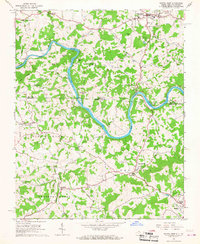
1966 Map of Sparta West
USGS Topo · Published 1968About this map
The New River carves a winding path through the borderlands between North Carolina and Virginia, defining the topographic character of Gap Civil and Prathers Creek. This mid-1960s survey captures a landscape transition where traditional mountain settlements like Bridle Creek and Stratford sit alongside mid-century developments. The map reveals a dense network of local landmarks, including the New River Country Club and a Drive-in Theater near Twin Oaks. Social life in the region is anchored by numerous small congregations, such as White Plains Ch and Osborne Memorial Ch, scattered among the ridges. Distinctive terrain features like Penitentiary Hill and Saddle Ridge overlook the river valley, while the local infrastructure is detailed down to the Sewage Disposal plant near Independence.
Find a feature on this map
48 named features on this map. Tap any name to fly to it.
Don’t see what you’re looking for? This feature index may not catch every label — zoom into the map to look around manually.
Map Details
Editions of this 1966 Sparta West Map
2 editions found
Other maps of this area

1889 · Wytheville
USGS Topo · 1:125,000

1889 · Wilkesboro
USGS Topo · 1:125,000

1891 · Wilkesboro
USGS Topo · 1:125,000

1892 · Wytheville
USGS Topo · 1:125,000

1930 · Independence
USGS Topo · 1:48,000

1933 · Independence
USGS Topo · 1:62,500

1935 · Mouth of Wilson
USGS Topo · 1:48,000

1935 · Middle Fox Creek
USGS Topo · 1:24,000

1940 · Mouth of Wilson
USGS Topo · 1:62,500

1953 · Winston-Salem
USGS Topo · 1:250,000