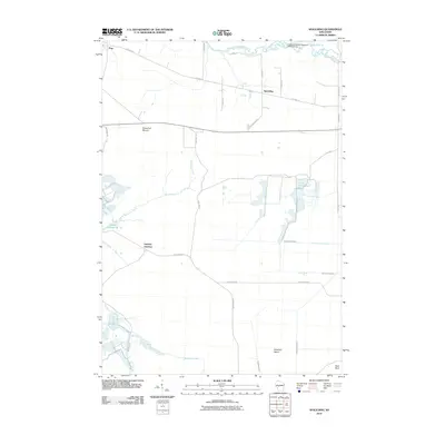
2010 Map of Spaulding
USGS Topo · Published 2010About this map
Spaulding and Pray anchor this portion of Jackson County, where the landscape is defined by an intricate network of waterways and managed marshes. The East Fork Black River cuts through the northern section, feeding into the Cranberry Marsh Reservoir 2WP1503 Dam. This region is heavily shaped by hydrological engineering, as evidenced by the series of drainage systems including the North Floater Ditch, South Floater Ditch, and Hunters Peak Ditch. These features point to a history of commercial cranberry cultivation and water management in the Central Wisconsin wetlands.
Find a feature on this map
29 named features on this map. Tap any name to fly to it.
Don’t see what you’re looking for? This feature index may not catch every label — zoom into the map to look around manually.
Map Details
Editions of this 2010 Spaulding Map
This is the sole edition of this map. No revisions or reprints were ever made.
Other maps of this area

1947 · Millston
USGS Topo · 1:62,500

1949 · Millston
USGS Topo · 1:62,500

1953 · Eau Claire
USGS Topo · 1:250,000

1957 · City Point
USGS Topo · 1:48,000

1958 · Eau Claire
USGS Topo · 1:250,000

1958 · Hatfield
USGS Topo · 1:48,000

1958 · Wyeville
USGS Topo · 1:48,000

1964 · Eau Claire
USGS Topo · 1:250,000

1970 · City Point NE
USGS Topo · 1:24,000
1970 · Mather
USGS Topo · 1:24,000