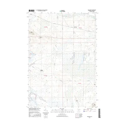
2015 Map of Spaulding
USGS Topo · Published 2015About this map
The East Fork Black River defines the northern reaches of this Jackson County landscape, flowing through a region where glacial geography and human drainage systems meet. Small settlements like Pray and Spaulding sit along Old Hwy 54, marking the historical transit corridor across the marshy interior. The terrain is notably punctuated by isolated elevations such as Saddle Mound, Sugarloaf Mound, and Bear Bluff, which rise sharply from the surrounding lowlands. A complex network of engineered waterways, including N Floater Ditch, Goodyear Ditch, and Hunters Peak Ditch, illustrates a concerted effort to manage the local hydrology for agricultural or industrial use. Near the southern edge, Potter Flowage and the namesake Deer Island and Drescher Island emerge from the wetland expanses, while Lapham Junction serves as a reminder of the area's older transportation hubs.
Find a feature on this map
36 named features on this map. Tap any name to fly to it.
Don’t see what you’re looking for? This feature index may not catch every label — zoom into the map to look around manually.
Map Details
Editions of this 2015 Spaulding Map
This is the sole edition of this map. No revisions or reprints were ever made.
Other maps of this area

1947 · Millston
USGS Topo · 1:62,500

1949 · Millston
USGS Topo · 1:62,500

1953 · Eau Claire
USGS Topo · 1:250,000

1957 · City Point
USGS Topo · 1:48,000

1958 · Eau Claire
USGS Topo · 1:250,000

1958 · Hatfield
USGS Topo · 1:48,000

1958 · Wyeville
USGS Topo · 1:48,000

1964 · Eau Claire
USGS Topo · 1:250,000

1970 · City Point NE
USGS Topo · 1:24,000
1970 · Mather
USGS Topo · 1:24,000