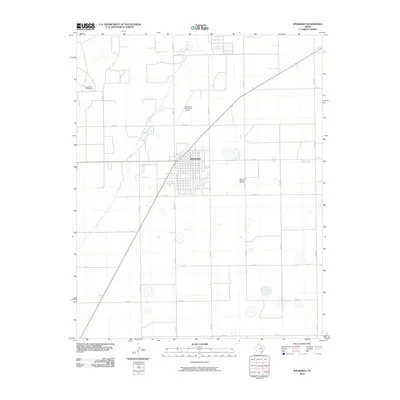
2010 Map of Spearman
USGS Topo · Published 2010About this map
Spearman serves as the focal point of this High Plains landscape, situated at the intersection of several farm-to-market roads. The town's grid is bounded to the north by the Spearman Municipal Airport and to the south by the Spearman Gas and Oil Field, highlighting the region's historical reliance on energy extraction. Water is a defining feature of the western terrain, where the meandering path of Horse Creek cuts through the otherwise geometric regularity of the Texas Panhandle's section lines. The map documents a highly structured agricultural and industrial environment, defined by a dense network of county roads like Co RD S and Co RD Aa that facilitate movement between the town center and the surrounding fields. The inclusion of the Spearman Golf Course on the northwestern edge of town illustrates the community's established infrastructure and social layout during this era.
Find a feature on this map
22 named features on this map. Tap any name to fly to it.
Don’t see what you’re looking for? This feature index may not catch every label — zoom into the map to look around manually.
Map Details
Editions of this 2010 Spearman Map
This is the sole edition of this map. No revisions or reprints were ever made.
Other maps of this area

1954 · Perryton
USGS Topo · 1:250,000

1958 · Perryton
USGS Topo · 1:250,000

1962 · Kimball
USGS Topo · 1:24,000

1962 · Hansford
USGS Topo · 1:24,000

1962 · Waka SW
USGS Topo · 1:24,000

1962 · Spearman
USGS Topo · 1:24,000

1973 · Waka
USGS Topo · 1:24,000

1973 · Spearman NE
USGS Topo · 1:24,000

1973 · Spearman SE
USGS Topo · 1:24,000
1974 · Holt
USGS Topo · 1:24,000