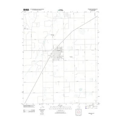
2012 Map of Spearman
USGS Topo · Published 2012About this map
Spearman serves as the primary hub of this northern Texas Panhandle landscape, where the town's residential street grid is organized around central arteries like E Kenneth Ave and N Bernice St. The surrounding countryside reflects a classic High Plains economy, dominated by large-scale agricultural blocks and the extensive Spearman Gas and Oil Field that underlies much of the territory east of the settlement. To the west, the winding path of Horse Cr provides the only significant natural relief to the flat, surveyed terrain.
Find a feature on this map
48 named features on this map. Tap any name to fly to it.
Don’t see what you’re looking for? This feature index may not catch every label — zoom into the map to look around manually.
Map Details
Editions of this 2012 Spearman Map
This is the sole edition of this map. No revisions or reprints were ever made.
Other maps of this area

1954 · Perryton
USGS Topo · 1:250,000

1958 · Perryton
USGS Topo · 1:250,000

1962 · Kimball
USGS Topo · 1:24,000

1962 · Hansford
USGS Topo · 1:24,000

1962 · Waka SW
USGS Topo · 1:24,000

1962 · Spearman
USGS Topo · 1:24,000

1973 · Waka
USGS Topo · 1:24,000

1973 · Spearman NE
USGS Topo · 1:24,000

1973 · Spearman SE
USGS Topo · 1:24,000
1974 · Holt
USGS Topo · 1:24,000