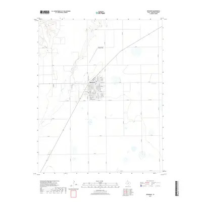
2019 Map of Spearman
USGS Topo · Published 2019About this map
Spearman serves as the focal point of this High Plains landscape, exhibiting a dense residential grid that defines the local community. The town's layout is centered around arterial routes such as E Kenneth Ave and Fm 760, which facilitate movement across the flat, open terrain of Hansford County. To the north, Major Samuel B Cornelius Field provides a critical aviation link for this agricultural region, while Horse Cr meanders through the western portion of the quadrangle, carving a subtle drainage path through the surrounding fields. The street-level detail in the town center includes specifically named thoroughfares like Hancock St and Old Airport Rd, reflecting the localized infrastructure of the 21st-century Texas Panhandle. This survey illustrates the contrast between the organized urban geometry of the settlement and the expansive, sectioned farmland that extends to the horizon.
Find a feature on this map
63 named features on this map. Tap any name to fly to it.
Don’t see what you’re looking for? This feature index may not catch every label — zoom into the map to look around manually.
Map Details
Editions of this 2019 Spearman Map
This is the sole edition of this map. No revisions or reprints were ever made.
Other maps of this area

1954 · Perryton
USGS Topo · 1:250,000

1958 · Perryton
USGS Topo · 1:250,000

1962 · Kimball
USGS Topo · 1:24,000

1962 · Hansford
USGS Topo · 1:24,000

1962 · Waka SW
USGS Topo · 1:24,000

1962 · Spearman
USGS Topo · 1:24,000

1973 · Waka
USGS Topo · 1:24,000

1973 · Spearman NE
USGS Topo · 1:24,000

1973 · Spearman SE
USGS Topo · 1:24,000
1974 · Holt
USGS Topo · 1:24,000