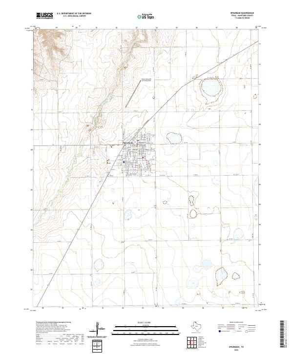
2022 Map of Spearman
USGS Topo · Published 2022About this map
Spearman serves as the focal point of this High Plains landscape, where the grid-iron street pattern of the city center transitions abruptly into a vast network of section roads. The Hansford County Courthouse stands at the heart of the settlement, anchoring the local government and civic life of the county seat. This modern topographic record illustrates the intersection of agricultural transport and aviation, with Major Samuel B Cornelius Field situated just north of the city. The surrounding terrain is defined by the ephemeral drainage of Horse Cr, which carves subtle relief into the flat plains to the west. A complex system of farm-to-market roads, including FM 760, FM 2387, and FM 759, facilitates the movement of goods through this productive panhandle region.
Find a feature on this map
60 named features on this map. Tap any name to fly to it.
Don’t see what you’re looking for? This feature index may not catch every label — zoom into the map to look around manually.
Map Details
Editions of this 2022 Spearman Map
This is the sole edition of this map. No revisions or reprints were ever made.
Other maps of this area

1954 · Perryton
USGS Topo · 1:250,000

1958 · Perryton
USGS Topo · 1:250,000

1962 · Kimball
USGS Topo · 1:24,000

1962 · Hansford
USGS Topo · 1:24,000

1962 · Waka SW
USGS Topo · 1:24,000

1962 · Spearman
USGS Topo · 1:24,000

1973 · Waka
USGS Topo · 1:24,000

1973 · Spearman NE
USGS Topo · 1:24,000

1973 · Spearman SE
USGS Topo · 1:24,000
1974 · Holt
USGS Topo · 1:24,000