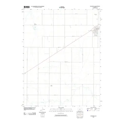
2009 Map of Spearville
USGS Topo · Published 2009About this map
Spearville sits at the northeastern corner of this Ford County landscape, organized around a grid that includes E Santa Fe St and Park St. The town's local history is anchored by Saint Johns Cemetery and the northern Silent Land Cemetery, which serve as quiet landmarks for the community. Southwest of the town center, Shehan Airpark provides a functional hub for local aviation, while the surrounding rural landscape is defined by a strict section-line road network.
Find a feature on this map
22 named features on this map. Tap any name to fly to it.
Don’t see what you’re looking for? This feature index may not catch every label — zoom into the map to look around manually.
Map Details
Editions of this 2009 Spearville Map
This is the sole edition of this map. No revisions or reprints were ever made.
Other maps of this area

1892 · Spearville
USGS Topo · 1:125,000

1894 · Spearville
USGS Topo · 1:125,000

1955 · Pratt
USGS Topo · 1:250,000

1959 · Pratt
USGS Topo · 1:250,000

1969 · Fort Dodge
USGS Topo · 1:24,000

1969 · Bucklin NW
USGS Topo · 1:24,000

1969 · Ford
USGS Topo · 1:24,000
1972 · Bellefont
USGS Topo · 1:24,000
1972 · Wright
USGS Topo · 1:24,000
1972 · Spearville
USGS Topo · 1:24,000