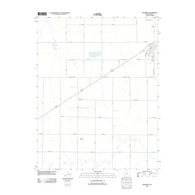
2012 Map of Spearville
USGS Topo · Published 2012About this map
Spearville sits at the heart of this Ford County landscape, where the traditional grid of the High Plains meets modern energy infrastructure. The 2012 survey illustrates the town's compact residential core, centered on streets like E Santa Fe St and N Main St, while the surrounding countryside is defined by the massive Spearville Wind Farm to the northeast. This juxtaposition of a classic agricultural hub with renewable energy development marks a significant transition in the local economy. Genealogists and local historians can locate established burial sites such as Silent Land Cem and Saint Johns Cem, which anchor the community's history. The drainage of Coon Creek and Cow Creek winds through the predominantly flat terrain, interspersed with local landmarks like Hain's Lake and the Shehan Airpark, reflecting the region's reliance on both aviation and water management in a semi-arid environment.
Find a feature on this map
28 named features on this map. Tap any name to fly to it.
Don’t see what you’re looking for? This feature index may not catch every label — zoom into the map to look around manually.
Map Details
Editions of this 2012 Spearville Map
This is the sole edition of this map. No revisions or reprints were ever made.
Other maps of this area

1892 · Spearville
USGS Topo · 1:125,000

1894 · Spearville
USGS Topo · 1:125,000

1955 · Pratt
USGS Topo · 1:250,000

1959 · Pratt
USGS Topo · 1:250,000

1969 · Fort Dodge
USGS Topo · 1:24,000

1969 · Bucklin NW
USGS Topo · 1:24,000

1969 · Ford
USGS Topo · 1:24,000
1972 · Bellefont
USGS Topo · 1:24,000
1972 · Wright
USGS Topo · 1:24,000
1972 · Spearville
USGS Topo · 1:24,000