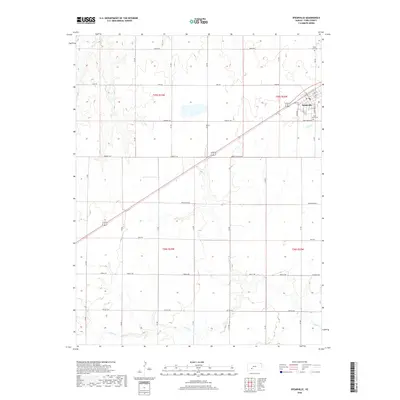
2018 Map of Spearville
USGS Topo · Published 2018About this map
Spearville serves as the primary hub on this Ford County landscape, situated along a prominent diagonal transportation corridor that cuts through the grid-iron road system of the High Plains. The town is flanked by local landmarks such as Saint John's Cem to the south and Silent Land Cem to the north, providing clear points of interest for genealogists tracing regional family history. The surrounding terrain is defined by the ephemeral drainages of Cow Cr and Coon Cr, which meander through sections of the Public Land Survey System defined by townships like t25s r23w. Notable for its geometric precision, the area is partitioned by named routes such as Correction Line Rd and Lutheran Rd, reflecting the systematic agricultural settlement of western Kansas. Small water bodies like Hains Lake punctuate the open country between established farmstead roads.
Find a feature on this map
25 named features on this map. Tap any name to fly to it.
Don’t see what you’re looking for? This feature index may not catch every label — zoom into the map to look around manually.
Map Details
Editions of this 2018 Spearville Map
This is the sole edition of this map. No revisions or reprints were ever made.
Other maps of this area

1892 · Spearville
USGS Topo · 1:125,000

1894 · Spearville
USGS Topo · 1:125,000

1955 · Pratt
USGS Topo · 1:250,000

1959 · Pratt
USGS Topo · 1:250,000

1969 · Fort Dodge
USGS Topo · 1:24,000

1969 · Bucklin NW
USGS Topo · 1:24,000

1969 · Ford
USGS Topo · 1:24,000
1972 · Bellefont
USGS Topo · 1:24,000
1972 · Wright
USGS Topo · 1:24,000
1972 · Spearville
USGS Topo · 1:24,000