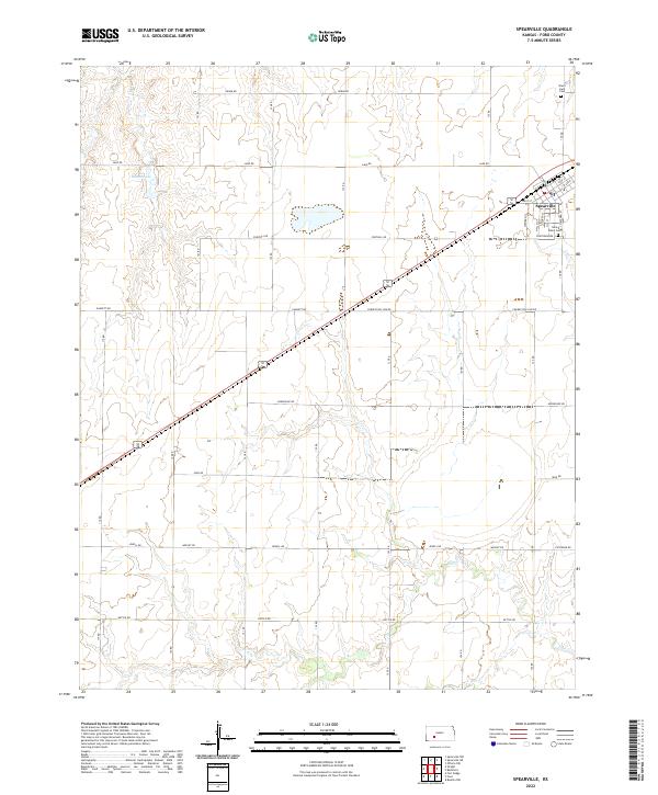
2022 Map of Spearville
USGS Topo · Published 2022About this map
Spearville sits at the heart of this Ford County landscape, where the intersection of organized town blocks meets the vast agricultural sections of the Kansas plains. The town's layout is defined by residential streets such as Western St, Sophy St, and S Stafford St, which extend toward the open countryside. Local genealogy and history are preserved at Saint John's Cem on the southern edge of town and Silent Land Cem to the north. Beyond the town limits, the terrain is shaped by intermittent waterways and local basins like Hains Lake, with drainage provided by the meandering paths of Coon Cr and Cow Cr. A rigorous grid of rural thoroughfares, including Denim Rd, Foothill Rd, and Correction Line Rd, facilitates the agricultural industry that has long sustained this region.
Find a feature on this map
31 named features on this map. Tap any name to fly to it.
Don’t see what you’re looking for? This feature index may not catch every label — zoom into the map to look around manually.
Map Details
Editions of this 2022 Spearville Map
This is the sole edition of this map. No revisions or reprints were ever made.
Other maps of this area

1892 · Spearville
USGS Topo · 1:125,000

1894 · Spearville
USGS Topo · 1:125,000

1955 · Pratt
USGS Topo · 1:250,000

1959 · Pratt
USGS Topo · 1:250,000

1969 · Fort Dodge
USGS Topo · 1:24,000

1969 · Bucklin NW
USGS Topo · 1:24,000

1969 · Ford
USGS Topo · 1:24,000
1972 · Bellefont
USGS Topo · 1:24,000
1972 · Wright
USGS Topo · 1:24,000
1972 · Spearville
USGS Topo · 1:24,000