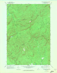
1970 Map of Speckled Mountain
USGS Topo · Published 1972About this map
White Mountain National Forest dominates this Oxford County landscape, which by 1970 was managed for recreation and conservation. The settlement of Hastings sits along the Wild River, while further south, the Speckled Mtn Lookout Tower serves as a high-altitude sentinel overlooking the Batchelders Grant. The map details a network of early forest roads and recreational infrastructure, including the Evans Notch Overlook and the Bickford Jeep Trail, indicating the shift toward outdoor tourism in this part of Maine. Water features define the drainage patterns of the region, from the cascading Kees Falls to the quiet waters of Shell Pond and Little Pond. Local history is noted in the smaller details, such as a Cem in the southern portion near Mason Hill and a Gravel Pit along the edge of Lovell.
Find a feature on this map
62 named features on this map. Tap any name to fly to it.
Don’t see what you’re looking for? This feature index may not catch every label — zoom into the map to look around manually.
Map Details
Editions of this 1970 Speckled Mountain Map
4 editions found
Other maps of this area

1893 · Gorham
USGS Topo · 1:62,500

1894 · North Conway
USGS Topo · 1:62,500

1896 · North Conway
USGS Topo · 1:62,500

1896 · Gorham
USGS Topo · 1:62,500

1909 · Fryeburg
USGS Topo · 1:62,500

1911 · Fryeburg
USGS Topo · 1:62,500

1914 · Bethel
USGS Topo · 1:62,500

1937 · Gorham
USGS Topo · 1:48,000

1940 · Bethel
USGS Topo · 1:62,500

1941 · Bethel
USGS Topo · 1:62,500