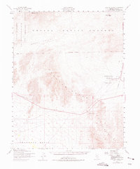
1952 Map of Specter Range
USGS Topo · Published 1975About this map
Nevada Proving Grounds and the Las Vegas Bombing and Gunnery Range dominate the northern landscape of this 1952 topographic survey. This era marks a significant period of military activity in the region, evidenced by the presence of Camp Desert Rock and the settlement of Mercury. The map details the logistical infrastructure required for these operations, including a dedicated Airstrip and a network of unimproved roads crossing Mercury Valley.
Find a feature on this map
21 named features on this map. Tap any name to fly to it.
Don’t see what you’re looking for? This feature index may not catch every label — zoom into the map to look around manually.
Map Details
Editions of this 1952 Specter Range Map
3 editions found
Other maps of this area

1907 · Las Vegas
USGS Topo · 1:250,000

1908 · Furnace Creek
USGS Topo · 1:250,000

1908 · Las Vegas
USGS Topo · 1:250,000

1910 · Furnace Creek
USGS Topo · 1:250,000

1942 · Indian Spring
USGS Topo · 1:125,000

1942 · Skull Mountain
USGS Topo · 1:125,000

1948 · Death Valley
USGS Topo · 1:250,000

1952 · Topopah Spring
USGS Topo · 1:62,500

1952 · Ash Meadows
USGS Topo · 1:62,500

1952 · Specter Range
USGS Topo · 1:62,500