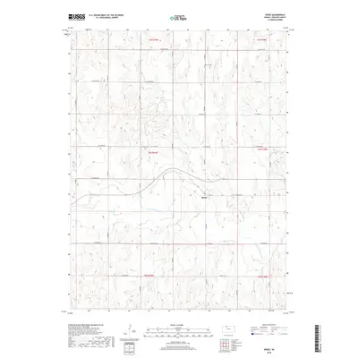
2018 Map of Speed
USGS Topo · Published 2018About this map
The N Fork Solomon River meanders through this portion of Phillips County, carving a valley across a landscape defined by traditional section-line navigation. The small settlement of Speed serves as a local anchor along Sand St, situated just north of the river's main channel. This area of Kansas is characterized by a series of drainage creeks, including Ash Cr and Wolf Cr, which feed into the larger Solomon River system.
Find a feature on this map
20 named features on this map. Tap any name to fly to it.
Don’t see what you’re looking for? This feature index may not catch every label — zoom into the map to look around manually.
Map Details
Editions of this 2018 Speed Map
This is the sole edition of this map. No revisions or reprints were ever made.
Other maps of this area

1893 · Norton
USGS Topo · 1:125,000

1893 · Phillipsburg
USGS Topo · 1:125,000

1955 · Beloit
USGS Topo · 1:250,000

1959 · Beloit
USGS Topo · 1:250,000

1972 · Speed
USGS Topo · 1:24,000

1972 · Glade SW
USGS Topo · 1:24,000

1972 · Phillipsburg South
USGS Topo · 1:24,000
1972 · Glade SE
USGS Topo · 1:24,000
1973 · Phillipsburg North
USGS Topo · 1:24,000
1973 · Stuttgart
USGS Topo · 1:24,000