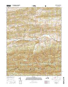
2016 Map of Speedwell
USGS Topo · Published 2016About this map
Cripple Creek meanders through the central valley of this Wythe County landscape, anchoring a string of historic communities including Speedwell, Collier, and Simmerman. The 2016 survey illustrates a rural Appalachian environment where narrow hollows like Andrews Hollow and Claybank Hollow give way to the prominent ridges of the Jefferson National Forest. This modern record is particularly valuable for genealogists, as it meticulously plots local landmarks like the Zion Church and Zion Cem, alongside the Speedwell Methodist Cem. The transportation network is defined by the Grayson Tpke, which follows the natural gaps in the terrain, such as Dry Run Gap, connecting the highland settlements to Rowe Crossroads. The juxtaposition of established family-named sites like Henley Mtn and Matney Flat against the protected forest boundaries provides a clear picture of contemporary land use in Southwest Virginia.
Find a feature on this map
72 named features on this map. Tap any name to fly to it.
Don’t see what you’re looking for? This feature index may not catch every label — zoom into the map to look around manually.
Map Details
Editions of this 2016 Speedwell Map
This is the sole edition of this map. No revisions or reprints were ever made.
Other maps of this area

1889 · Wytheville
USGS Topo · 1:125,000

1892 · Wytheville
USGS Topo · 1:125,000

1930 · Speedwell
USGS Topo · 1:62,500

1930 · Independence
USGS Topo · 1:48,000

1931 · Rural Retreat
USGS Topo · 1:48,000

1933 · Independence
USGS Topo · 1:62,500

1935 · Mouth of Wilson
USGS Topo · 1:48,000

1935 · Cedar Springs
USGS Topo · 1:24,000
1935 · Groseclose
USGS Topo · 1:24,000

1935 · Middle Fox Creek
USGS Topo · 1:24,000