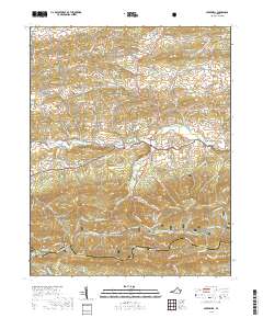
2019 Map of Speedwell
USGS Topo · Published 2019About this map
Cripple Creek flows through a valley defined by rural settlements and mountainous terrain along the Wythe Co Grayson Co border. The village of Speedwell serves as a central point, situated near the Speedwell Methodist Cem and the prominent Cave Hill. To the north, Rowe Crossroads and Simmerman mark the agricultural landscape, while the southern half of the map is dominated by the ridges of the Jefferson National Forest. This high country includes notable summits such as Perkins Knob, Porter Mtn, and the curiously named Horse Heaven. The map reveals a network of old thoroughfares like the Grayson Tpke and Zion Church Rd, which pass by local landmarks like Zion Church and Zion Cem. These features illustrate the enduring community structure of this pocket of the Blue Ridge, where deep hollows like Claybank Hollow and Laurel Hollow separate narrow ridges and upland plateaus.
Find a feature on this map
81 named features on this map. Tap any name to fly to it.
Don’t see what you’re looking for? This feature index may not catch every label — zoom into the map to look around manually.
Map Details
Editions of this 2019 Speedwell Map
This is the sole edition of this map. No revisions or reprints were ever made.
Other maps of this area

1889 · Wytheville
USGS Topo · 1:125,000

1892 · Wytheville
USGS Topo · 1:125,000

1930 · Speedwell
USGS Topo · 1:62,500

1930 · Independence
USGS Topo · 1:48,000

1931 · Rural Retreat
USGS Topo · 1:48,000

1933 · Independence
USGS Topo · 1:62,500

1935 · Mouth of Wilson
USGS Topo · 1:48,000

1935 · Cedar Springs
USGS Topo · 1:24,000
1935 · Groseclose
USGS Topo · 1:24,000

1935 · Middle Fox Creek
USGS Topo · 1:24,000