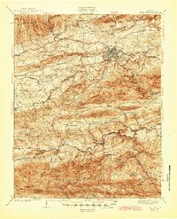
1939 Map of Speedwell
USGS Topo · Published 1945About this map
Wytheville serves as the regional anchor on this map, showing the town's early 20th-century footprint as a hub for the Norfolk and Western Railway. The landscape transitions from the urban rail corridor of the Lee Highway into the deep terrain of the Jefferson National Forest, where the Appalachian Trail winds through the high ridges. This era reflects a rural economy still heavily tied to the land and localized industry, evidenced by the Little Wythe Furnace near Cripple Creek. The surrounding countryside is dotted with a high density of neighborhood institutions like New Hope Ch, Zion Sch, and Mountain View School, revealing the scattered nature of settlements such as Favonia and Simmerman before modern consolidation.
Find a feature on this map
112 named features on this map. Tap any name to fly to it.
Don’t see what you’re looking for? This feature index may not catch every label — zoom into the map to look around manually.
Map Details
Editions of this 1939 Speedwell Map
3 editions found
Other maps of this area

1887 · Pocahontas
USGS Topo · 1:125,000

1889 · Hillsville
USGS Topo · 1:125,000

1889 · Wytheville
USGS Topo · 1:125,000

1890 · Dublin
USGS Topo · 1:125,000

1891 · Pocahontas
USGS Topo · 1:125,000

1891 · Dublin
USGS Topo · 1:125,000

1892 · Hillsville
USGS Topo · 1:125,000

1892 · Wytheville
USGS Topo · 1:125,000

1894 · Pocahontas
USGS Topo · 1:125,000

1895 · Pocahontas
USGS Topo · 1:125,000