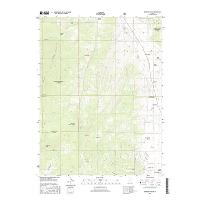
2017 Map of Spencer Canyon
USGS Topo · Published 2017About this map
Indianola serves as a focal point in this high-altitude landscape where the boundaries of the Manti-Lasal National Forest and Uinta National Forest converge. The terrain is defined by deep drainages like Spencer Canyon and its tributaries, the Left Fork and Right Fork, which carve through the Wasatch Range. Higher elevations are marked by landmarks such as Mt Baldy and the elongated Hop Creek Ridge.
Find a feature on this map
53 named features on this map. Tap any name to fly to it.
Don’t see what you’re looking for? This feature index may not catch every label — zoom into the map to look around manually.
Map Details
Editions of this 2017 Spencer Canyon Map
This is the sole edition of this map. No revisions or reprints were ever made.
Other maps of this area

1885 · Manti
USGS Topo · 1:250,000

1895 · Manti
USGS Topo · 1:250,000

1951 · Moroni
USGS Topo · 1:62,500

1952 · Santaquin Peak
USGS Topo · 1:62,500

1956 · Price
USGS Topo · 1:250,000

1960 · Price
USGS Topo · 1:250,000

1962 · Price
USGS Topo · 1:250,000
1967 · Indianola
USGS Topo · 1:24,000
1967 · Thistle
USGS Topo · 1:24,000
1967 · Fairview
USGS Topo · 1:24,000