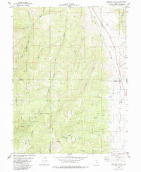
1979 Map of Spencer Canyon
USGS Topo · Published 1985About this map
Manti-La Sal National Forest and Uinta National Forest converge in this high-elevation landscape along the borders of Utah, Sanpete, and Juab counties. The eastern edge is defined by the Denver and Rio Grande Western railroad corridor, which follows the path of Thistle Creek. This transportation artery contrasts with the remote interior, where numerous canyons like Spencer Canyon and Losty Canyon drain toward the valley. The map reveals a network of high-country resources including Madsen Lake, Blind Lake, and Hartney Lake situated beneath the prominence of Mt Baldy. The presence of several Pack Trails and a Jeep Trail suggests a landscape utilized for livestock movement and backcountry access between the various forks and ridges that characterize this portion of the Wasatch Range.
Find a feature on this map
41 named features on this map. Tap any name to fly to it.
Don’t see what you’re looking for? This feature index may not catch every label — zoom into the map to look around manually.
Map Details
Editions of this 1979 Spencer Canyon Map
This is the sole edition of this map. No revisions or reprints were ever made.
Other maps of this area

1885 · Manti
USGS Topo · 1:250,000

1895 · Manti
USGS Topo · 1:250,000

1951 · Moroni
USGS Topo · 1:62,500

1952 · Santaquin Peak
USGS Topo · 1:62,500

1956 · Price
USGS Topo · 1:250,000

1960 · Price
USGS Topo · 1:250,000

1962 · Price
USGS Topo · 1:250,000
1967 · Indianola
USGS Topo · 1:24,000
1967 · Thistle
USGS Topo · 1:24,000
1967 · Fairview
USGS Topo · 1:24,000