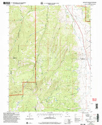
2001 Map of Spencer Canyon
USGS Topo · Published 2004About this map
The boundary between Uinta National Forest and Manti-La Sal National Forest defines this mountainous stretch of the Wasatch Range. Reaching southward toward the Sanpete County line, the terrain is deeply incised by drainages such as Wash Canyon and Losty Canyon, which flow toward the Thistle Creek corridor. High-elevation features like Mount Baldy and Madsen Lake anchor the southern portion of the sheet, providing a clear look at the subalpine geography of central Utah as it was documented at the start of the 21st century. The map traces the winding Summit Trail along the western ridges, including Hop Creek Ridge, while a prominent Pipeline cuts across the northeastern topography, marking the intersection of natural wilderness and modern infrastructure.
Find a feature on this map
34 named features on this map. Tap any name to fly to it.
Don’t see what you’re looking for? This feature index may not catch every label — zoom into the map to look around manually.
Map Details
Editions of this 2001 Spencer Canyon Map
This is the sole edition of this map. No revisions or reprints were ever made.
Other maps of this area

1885 · Manti
USGS Topo · 1:250,000

1895 · Manti
USGS Topo · 1:250,000

1951 · Moroni
USGS Topo · 1:62,500

1952 · Santaquin Peak
USGS Topo · 1:62,500

1956 · Price
USGS Topo · 1:250,000

1960 · Price
USGS Topo · 1:250,000

1962 · Price
USGS Topo · 1:250,000
1967 · Indianola
USGS Topo · 1:24,000
1967 · Thistle
USGS Topo · 1:24,000
1967 · Fairview
USGS Topo · 1:24,000