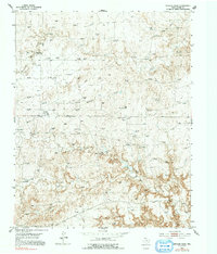
1953 Map of Spencer Draw
USGS Topo · Published 1991About this map
Browns Ranch (Aban d) stands as a notable marker of changing land use in this portion of Moore County, documented as abandoned by the mid-twentieth century. The landscape is defined by the complex drainage systems of Plum Creek, including its North Plum Creek and South Plum Creek forks, which carve through the plains alongside Spencer Draw.
Find a feature on this map
12 named features on this map. Tap any name to fly to it.
Don’t see what you’re looking for? This feature index may not catch every label — zoom into the map to look around manually.
Map Details
Editions of this 1953 Spencer Draw Map
2 editions found
Other maps of this area

1936 · Fourways
USGS Topo · 1:62,500

1939 · Sanford
USGS Topo · 1:62,500

1953 · Marsh
USGS Topo · 1:24,000

1953 · Alibates Ranch
USGS Topo · 1:24,000

1953 · Evans Canyon
USGS Topo · 1:24,000

1953 · Masterson
USGS Topo · 1:24,000

1953 · McDowell Creek
USGS Topo · 1:24,000

1953 · Spencer Draw
USGS Topo · 1:24,000

1954 · Amarillo
USGS Topo · 1:250,000

1958 · Amarillo
USGS Topo · 1:250,000