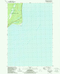
1989 Map of Spencer Lake
USGS Topo · Published 1989About this map
Lake Huron dominates this 1989 coastal survey, its expansive waters meeting the shoreline at Au Sable Point. The landscape is largely defined by the protected wilderness of the Huron National Forest, which covers the northern portion of the quadrangle. Inland from the coast, the topography is punctuated by Spencer Lake, a small water body situated within the township of Baldwin. The boundary between Au Sable and Baldwin townships runs through this wooded terrain, showing a region where natural preservation and seasonal lakefront geography intersect. This late-twentieth-century record emphasizes the shoreline’s bathymetry and the forest's interior roads, providing a clear view of the Iosco County coast before further modern development.
Find a feature on this map
8 named features on this map. Tap any name to fly to it.
Don’t see what you’re looking for? This feature index may not catch every label — zoom into the map to look around manually.
Map Details
Editions of this 1989 Spencer Lake Map
This is the sole edition of this map. No revisions or reprints were ever made.
Other maps of this area

1954 · Tawas City
USGS Topo · 1:250,000

1958 · Tawas City
USGS Topo · 1:250,000

1959 · East Tawas
USGS Topo · 1:62,500

1984 · Tawas City
USGS Topo · 1:100,000
1989 · Foote Site Village
USGS Topo · 1:24,000
1989 · East Tawas
USGS Topo · 1:24,000
1989 · Oscoda
USGS Topo · 1:24,000
2011 · East Tawas OE S
USGS Topo · 1:24,000
2012 · Foote Site Village
USGS Topo · 1:24,000
2012 · East Tawas
USGS Topo · 1:24,000