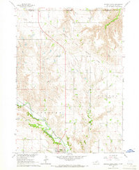
1964 Map of Spencer North
USGS Topo · Published 1966About this map
The Fort Randall Military Reservation Boundary cuts across the northern terrain of Boyd County, marking the transition from Nebraska into South Dakota. Just south of the state line, the community of Spencer (BM 1634) serves as a focal point for the surrounding agricultural landscape, which is defined by an intricate network of waterways including Randall Creek, Spring Creek, and Crooked Creek. This 1960s survey documents the rural character of the area, noting several country landmarks such as Messiah Ch, Baker Ch, and School No 52. The prevalence of small cemeteries like Immanuel Cem and Old Immanuel Cem alongside Ponca and North Western Creek offers genealogists a detailed look at the settlement patterns that persisted in the mid-20th century before modern consolidation.
Find a feature on this map
20 named features on this map. Tap any name to fly to it.
Don’t see what you’re looking for? This feature index may not catch every label — zoom into the map to look around manually.
Map Details
Editions of this 1964 Spencer North Map
This is the sole edition of this map. No revisions or reprints were ever made.
Other maps of this area

1951 · Bristow
USGS Topo · 1:24,000

1952 · Spencer South
USGS Topo · 1:24,000

1952 · Butte SE
USGS Topo · 1:24,000

1955 · Mitchell
USGS Topo · 1:250,000

1955 · O'Neill
USGS Topo · 1:250,000

1959 · O'Neill
USGS Topo · 1:250,000

1959 · Mitchell
USGS Topo · 1:250,000

1964 · Butte
USGS Topo · 1:24,000

1964 · Fort Randall Dam
USGS Topo · 1:24,000

1964 · Gross
USGS Topo · 1:24,000