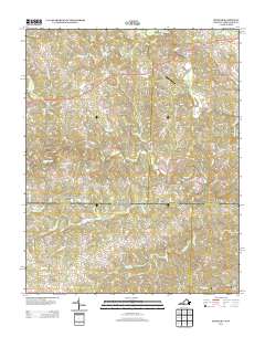
2013 Map of Spencer
USGS Topo · Published 2013About this map
N Mayo River and S Mayo River dominate the drainage of this Virginia-North Carolina borderland, shaping a landscape defined by meandering watercourses and small rural hubs. Amostown and Spencer anchor the local road network, while smaller named points like Old Well Crossing and Craig indicate traditional crossroads. The economic and social geography of the area is highlighted by industrial and infrastructure landmarks, including Sheppards Mill and Covington Airport.
Find a feature on this map
81 named features on this map. Tap any name to fly to it.
Don’t see what you’re looking for? This feature index may not catch every label — zoom into the map to look around manually.
Map Details
Editions of this 2013 Spencer Map
This is the sole edition of this map. No revisions or reprints were ever made.
Other maps of this area

1924 · Martinsville
USGS Topo · 1:48,000

1926 · Martinsville
USGS Topo · 1:62,500

1926 · Critz
USGS Topo · 1:48,000

1927 · Martinsville
USGS Topo · 1:62,500

1928 · Critz
USGS Topo · 1:62,500

1944 · Martinsville
USGS Topo · 1:62,500

1953 · Winston-Salem
USGS Topo · 1:250,000

1953 · Greensboro
USGS Topo · 1:250,000

1954 · Greensboro
USGS Topo · 1:250,000

1955 · Winston-Salem
USGS Topo · 1:250,000